


ATIS App
4.225.00 Reviews
App Specs
- Version
- 3.6.2
- Updated On
- License
- Free
- Downloads
- 10,000+
- Developer
- iawix ltd.
- Categories
- Weather
- Platform
- Android
Screenshots
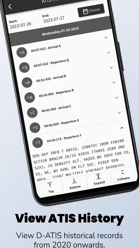
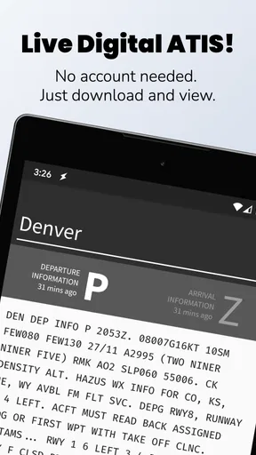
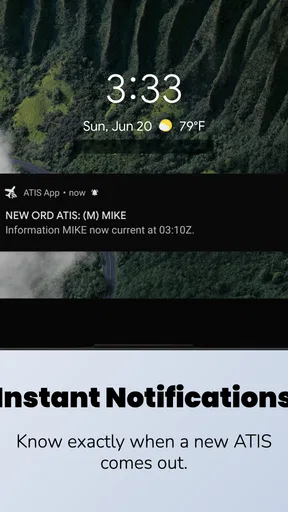
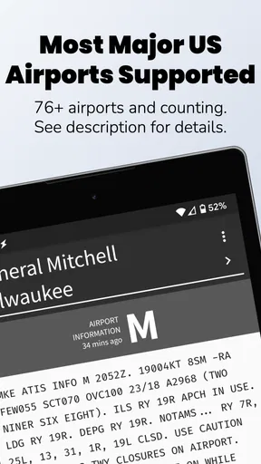
 Analysis by AppCompare
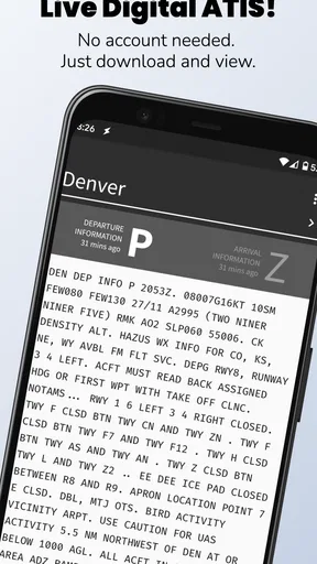
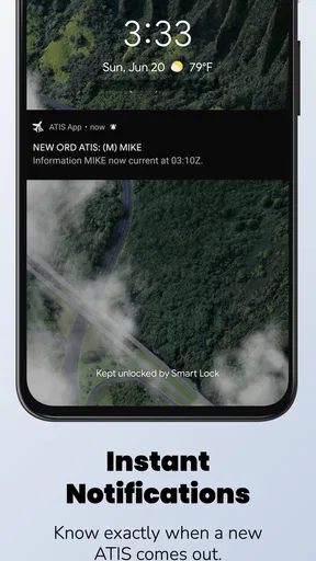
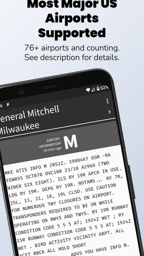
When I need a quick look at aviation weather information, I do not always want a general weather app filled with radar maps, pollen counts, forecasts, and unrelated alerts. ATIS App takes a narrower approach: it is a weather app from iawix ltd. built around live Digital ATIS reports from the FAA. That focus makes it interesting for pilots, student pilots, aviation students, and anyone who regularly needs airport information rather than a broad picture of the weather.
After using it, my view is fairly simple. This is not an all-purpose replacement for a normal weather service, and it should not be treated as one. Its value comes from reducing the distance between the user and a specific aviation information source. If that is the information you actually need, the small scope feels practical. If you mainly want a weekend forecast, hourly temperatures, or a visual storm map, the app is pointed at the wrong problem.
What to consider before choosing an aviation weather app
The first decision is whether you need an official-style airport information workflow or a general weather overview. A standard weather app is usually better for deciding what to wear, planning a drive, or checking rain later in the day. An aviation-oriented tool has a different job: helping you find the current airport information that matters before or during flight preparation.
With this app, I would begin by asking how often I need FAA Digital ATIS reports. If the answer is “only once in a while,” installing a dedicated tool may not change much. If I check airport information repeatedly, the focused design becomes more appealing because I am not searching through unrelated consumer-weather features every time.
The second question is how much context I expect around the report. ATIS App is centered on viewing live D-ATIS information. That is useful when the report itself is the priority, but it does not turn the application into a complete flight-planning suite. I would still use the appropriate official aviation resources and normal preflight procedures for the wider picture.
That distinction is important for new pilots. A convenient display can make information easier to reach, but convenience is not the same as completeness. I would use this app as one part of a preparation routine, not as permission to skip checking notices, charts, forecasts, airport status, or other required sources.
A focused tool instead of a crowded forecast screen
In my experience, the strongest reason to choose this app is concentration. General weather applications often make the user interpret several layers of information before finding anything relevant to an airport. Here, the central purpose is much clearer: access live Digital ATIS weather reports from the FAA.
Worth Reading Before You Choose

Flipboard Shows What News Apps Must Do Beyond the Feed

Switching to Android Auto Means Rethinking Your Driving Routine

Google Calendar Makes a Crowded Week Easier to Manage

Ludo King Makes the Most of the Minutes Between Plans

Baby Panda World Brings Quick Play to Modern Phones, but Its Game Library Feels Busy

ESPN’s Live Game View Makes Following Close Games Easier
That focus can also make the app less intimidating for someone who does not need a full meteorological dashboard. A student reviewing airport information before a lesson may prefer a direct route to the report instead of learning a large collection of unrelated controls. The trade-off is that a narrow tool naturally answers fewer questions.
I also think the app makes more sense on a phone used as a quick reference than on a device intended to manage every part of a flight. It can sit alongside a charting application, briefing workflow, or other aviation tools. Its role is specific, and that is precisely why it should be judged by speed of access and clarity rather than by the number of features found in larger platforms.
Who is most likely to benefit
Student pilots are a natural audience. During training, I often want to repeat the same information-gathering steps until they become routine. A dedicated ATIS viewer can help make that part of the process feel less scattered. It is also useful for pilots who already know which airport information they need and want a compact way to reach it.
Aviation enthusiasts may appreciate it for a different reason. Listening to or reading airport information is part of understanding how real operations work, and a live D-ATIS source is more relevant to that interest than a generic local forecast. Flight instructors could also find it handy as a supplementary reference when discussing how airport weather information fits into preparation.
On the other hand, casual users should think twice. If I only want to know whether I need an umbrella, this app adds a specialized step without giving me the familiar consumer forecast experience. It is also not the right first choice for someone looking for route planning, detailed map layers, or a single application that combines every aviation task.
Where ATIS App performs best in daily use
The app’s main strength is its clear purpose. The store summary describes live FAA D-ATIS weather reports, and that is the lens through which I would evaluate it. Rather than promising to be an entire aviation ecosystem, it presents itself as a focused way to view airport information.
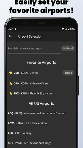
That can be helpful in a realistic situation. Imagine I am preparing for an evening training flight and want to check the airport’s current ATIS before opening the rest of my planning materials. I can use the dedicated app for that first aviation-specific check, note the relevant information, and then continue with the rest of the briefing. It does not replace the workflow; it gives one part of it a defined place.
A less obvious benefit is habit formation. When an app is designed around one recurring task, I am less tempted to browse through unrelated screens. For a student, that can encourage a consistent sequence: identify the airport, review the current report, compare it with the wider briefing, and confirm that the information is still current before relying on it.
Another useful trade-off is that the app’s narrow scope may reduce mental clutter. A large aviation application can be powerful, but power often comes with menus, layers, and settings that take time to learn. ATIS App is easier to understand conceptually because its purpose is limited. That does not guarantee that every user will prefer its interface, but the product idea itself is refreshingly direct.
How I would build it into a preflight routine
I would not open the app in isolation and immediately treat the displayed report as the complete weather picture. Instead, I would use it at a defined point in my routine. First, I would identify the airport and check the current D-ATIS information. Then I would move to the other official material needed for the flight, checking whether the report is still current and whether anything else changes the decision.
This approach makes the app more useful because it gives it a job rather than asking it to do everything. It also avoids a common mistake with specialized tools: confusing a convenient interface with a complete briefing. The best workflow is not “app instead of preparation”; it is “app as a focused part of preparation.”
For repeated use, I would keep the application near the other aviation tools on my device and open it before I start looking at broader conditions. That order is practical when the airport report is the first item I want to establish. If I am only checking general weather, I would skip it and use a conventional weather service instead.
Compatibility, maturity, and the practical cost
The app is free to install, carries an Everyone content rating, and supports Android devices running version 7.0 or later. That makes it accessible to many users with older compatible phones, which is useful for a secondary device kept in a flight bag. The current release is version 3.6.2, so I would still keep the application updated through the normal store process before depending on it regularly.
Its public footprint is modest but encouraging: it has passed ten thousand installs and holds a 4.2 average from sixty-nine ratings, with twenty-five written reviews. I would not treat those figures as proof that it fits every pilot, but they suggest that the app has found a real audience while remaining more specialized than mainstream weather products.
There are in-app purchases priced at $4.99 per item. Because the core download is free, I would install it first and see whether the free experience covers my actual use before paying for anything. The important question is not simply whether an optional purchase exists; it is whether the added value matches the frequency with which I need D-ATIS information.
That is also where switching cost matters. If I already use a flight-planning platform that includes the airport information I need, adding another app creates another place to check and another interface to maintain. The cost may be small in money, but it can be real in attention. I would keep ATIS App only if its focused access is quicker or clearer in my own routine.
Limitations that should shape expectations
The biggest limitation is the same thing that makes the app attractive: specialization. A live D-ATIS viewer is not automatically a substitute for a complete weather forecast, airport briefing, navigation tool, or flight-planning application. Users who expect all of those roles in one place may find the experience too narrow.
I would also be careful about relying on any live information without considering timing and operational context. A report can change, and a phone display should not become an excuse to ignore current procedures or other authoritative sources. The app can make access convenient, but the pilot still has to interpret the information responsibly.
There is another practical limitation for households where several people share one device. A general weather app serves many everyday needs, while this one serves a specific aviation need. If I am choosing one weather application for the whole family, I would choose the general option. If I am choosing a tool for my own aviation preparation, the focused purpose becomes much more relevant.
How it compares with the usual alternatives
Compared with a standard weather app, ATIS App wins on relevance for airport-specific aviation information and loses on breadth. A consumer app is better for visual forecasts, daily planning, and ordinary weather questions. This one is better when the question is specifically about accessing FAA Digital ATIS information.
Compared with a full aviation platform, it wins through simplicity and a smaller learning burden. A larger platform may be the better choice when I want several connected planning functions in one workflow. The focused app may be preferable when I already have those functions elsewhere and do not want to bury the ATIS step inside a larger system.
Compared with manually searching for the same information, a dedicated app can feel more convenient because it gives the task a permanent home on the phone. That convenience is most valuable for repeat users. For an occasional visitor, the benefit may not justify adding another application to the device.
The right comparison, then, is not “Which app has the most features?” It is “Where do I want this task to live?” If the answer is inside a broad flight-planning environment, use that environment. If the answer is a compact, purpose-built viewer for live D-ATIS reports, this app has a sensible place.
Questions I would answer before installing
If I were asked whether this is suitable for a beginner, I would say yes, as a supplementary learning tool, provided the beginner understands its limits. It can help establish familiarity with airport information, but it should sit inside instruction and proper preflight preparation rather than replace them.
If the question is whether it works as a normal daily weather app, my answer is no. Its purpose is too specialized for that. I would install it alongside a general weather application, not instead of one, unless my weather needs are almost entirely aviation-related.
If someone asks whether the free installation is enough to evaluate it, I would say yes. Since the app can be installed without an upfront charge, I would test the airport-report workflow during the situations where I actually need it. Only after that would I consider an optional purchase at $4.99 per item.
For someone with an older Android phone, the minimum requirement of Android 7.0 or later is the key check. If the device meets that requirement, the app is worth trying from a compatibility perspective. I would still test it before a time-sensitive flight rather than making a first installation part of an urgent departure routine.
Finally, if I already own a trusted aviation application that presents the same information in a workflow I understand, I would not switch automatically. The benefit has to be visible in daily use: fewer taps, clearer access, or a more comfortable way to review the report. Otherwise, keeping one established system may be safer and simpler.
My recommendation for the right kind of user
I recommend ATIS App to pilots, students, and aviation-minded users who specifically want a dedicated route to live FAA D-ATIS weather reports. The app’s free entry point, Everyone rating, and support for Android 7.0 or later make it easy to try, while its focused design gives it a clear role beside broader aviation tools.
I would not recommend it as the only weather application on a phone, and I would not choose it for general forecasts or complete flight planning. Those are situations where a conventional weather service or a more comprehensive aviation platform is likely to serve better.
My final judgment is that this is a useful specialist rather than a universal solution. ATIS App is worth keeping when direct access to airport information saves you time in a repeatable aviation routine. If that describes your needs, install it, test it alongside your existing briefing process, and judge it by how naturally it fits. If it does not, there is little reason to force a narrowly designed weather tool into a general-purpose role.
Pros
- Quick access to real-time public transport information.
- Clear route planning helps simplify daily commutes.
- Useful service updates can help users avoid unexpected delays.
- Supports more confident travel in unfamiliar areas.
- Convenient alternative to checking multiple transport sources.
Cons
- Information accuracy depends on the availability of local data.
- Some features may vary significantly by city or transport network.
- Requires an internet connection for live updates and route searches.
- Interface navigation may take time for first-time users.
- Battery and data usage can increase during frequent GPS tracking.
FAQs for ATIS App
What is the ATIS app used for?
ATIS is designed to provide aviation-related information through an Automatic Terminal Information Service. It can help users access current airport details such as weather conditions, runway information, active approaches, and other operational notices. The exact features may vary depending on the version and data sources available, so pilots should review the app’s coverage before relying on it for flight preparation or in-flight decisions.
Is ATIS suitable for pilots and aviation students?
The app can be useful for pilots, flight students, instructors, and aviation enthusiasts who want quick access to terminal information in a mobile format. Its interface may make reviewing airport conditions more convenient during planning. However, it should be treated as a supplementary tool rather than a replacement for official aviation publications, certified communication channels, or instructions received directly from air traffic control.
Does ATIS require an internet connection?
An internet connection may be necessary to retrieve updated airport, weather, or operational information, particularly when the app depends on live data services. Availability can also vary by location and provider coverage. Before using ATIS away from reliable connectivity, check whether the relevant information can be cached or accessed offline, and always prepare an alternative source for essential flight data.
Can ATIS information be trusted for real-time flight operations?
ATIS may provide helpful and timely information, but users should not assume that every item is updated instantly or that the app is an official substitute for airport broadcasts and air traffic control. Data interruptions, delays, technical problems, or regional limitations can occur. Pilots should verify important details with authoritative sources and follow current regulations and operational procedures.
Is the ATIS app free to download and use?
The download and available features may depend on the platform, developer, and current release. Some versions of aviation apps are free, while others may include advertising, subscriptions, in-app purchases, or restricted access to advanced information. It is worth checking the Google Play Store or Apple App Store listing for the latest pricing, permissions, compatibility requirements, and user reviews before installing.


